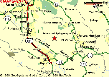
 This map, courtesy of Mapquest!,
shows the location of Lafferty Ranch as a red star. To see a broader or
finer view, click on the map to go to the Mapquest! site.
This map, courtesy of Mapquest!,
shows the location of Lafferty Ranch as a red star. To see a broader or
finer view, click on the map to go to the Mapquest! site.Lafferty Ranch Context Maps
This map, courtesy of Mapquest!,
shows the location of Lafferty Ranch as a red star. To see a broader or
finer view, click on the map to go to the Mapquest! site.
Use the arrows on the right side of the map to drill up to a regional map, or down to street detail.
You may also refer to one of the other Web mapping facilities, if you prefer. Search for the following, which would be Lafferty Ranch's street address if it had one: 2061 Sonoma Mountain Road, Petaluma, CA 94954.
![]()
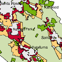 Here we see a portion of the Sonoma County "At Risk" Map for 1994 prepared by the Greenbelt Alliance.
Sonoma Mountain is the area of light green (signifying low risk, but
unprotected, greenbelt) in the center of the main urban areas of the
county: Santa Rosa, Rohnert Park and Cotati, Petaluma, and Sonoma.
Lafferty Ranch is the dark green rectangle (signifying secure greenbelt)
north of Petaluma near the center of that light green area. The small
dark green spot NNW of Lafferty is the Fairfield-Osborne Preserve. The
larger dark green area NNE of Lafferty is Jack London State Historic
Park, plus some adjoining open space associated with a state mental
health facility.
Here we see a portion of the Sonoma County "At Risk" Map for 1994 prepared by the Greenbelt Alliance.
Sonoma Mountain is the area of light green (signifying low risk, but
unprotected, greenbelt) in the center of the main urban areas of the
county: Santa Rosa, Rohnert Park and Cotati, Petaluma, and Sonoma.
Lafferty Ranch is the dark green rectangle (signifying secure greenbelt)
north of Petaluma near the center of that light green area. The small
dark green spot NNW of Lafferty is the Fairfield-Osborne Preserve. The
larger dark green area NNE of Lafferty is Jack London State Historic
Park, plus some adjoining open space associated with a state mental
health facility.
![]()
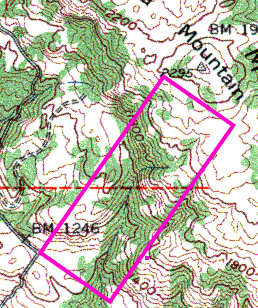 Here
is a portion of the USGS topographical map for the "Glen Ellen" segment
showing the boundaries and topographical features of Lafferty Ranch
(outlined in violet) and its immediate surroundings. The road in the lower
left is Sonoma Mountain Road. This map is rather old, circa 1980, so some
details are not up to date.
Here
is a portion of the USGS topographical map for the "Glen Ellen" segment
showing the boundaries and topographical features of Lafferty Ranch
(outlined in violet) and its immediate surroundings. The road in the lower
left is Sonoma Mountain Road. This map is rather old, circa 1980, so some
details are not up to date.
![]()